Mindulle Typhoon Threaten to Philippine and Japan
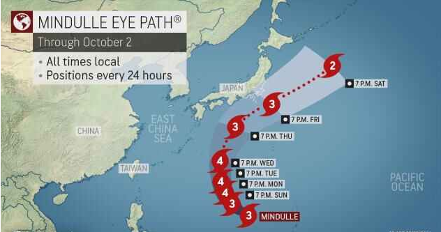
As Typhoon Mindulle grows in the Philippine Sea, climate analysts believe favorable circumstances for tropical development along its path might cause the storm to swiftly strengthen and become a super typhoon.
“As Mindulle moves through the Philippine Sea, it is predicted to strengthen into early next week,” stated Meteorologist.Warm water and mild vertical wind shear, along with favorable circumstances along the storm’s course, will allow for rapid strengthening until early next week.
When a storm’s maximum 1-minute sustained winds approach 150 mph (241 km/h), it is classified as a supert typhoon. In the Atlantic and eastern Pacific Oceans, this is equal to a powerful Category 4 hurricane on the Saffir-Simpson Hurricane Wind Scale.
Mindulle could strengthen to the equivalent of a Category 5 hurricane (maximum sustained winds of more than 157 mph (252 km/h) early next week.Even if the storm stays away from shore until the middle of next week, seas will rise over the Philippine Sea, creating hazardous boating conditions throughout the region.

Large swells can create hazardous swimming conditions, including powerful rip currents, on beaches in the western Pacific. Areas from the northeast Philippines to eastern Taiwan, as well as the Ryukyu Islands and mainland Japan, especially the south and east coasts of Kyushu, Shikoku, and Honshu, are likely to experience the most dangerous circumstances.
The storm is predicted to slow down and make a gradual shift to the north, then to the northeast, as it travels across the Philippine Sea next week.
“A slower shift to the northeast could result in the storm affecting southern Japan with heavy rain and gusty gusts during the second half of next week,” Metrologist warned. “A faster northeast turn could result in the outer bands brushing the southern coast of Japan.” Rain bands may begin to reach southern Japan during the middle of the week as Mindulle turns north and northeast.
The amount of rain and wind each place receives will be determined by how close the typhoon eventually tracks to these areas. If the center track comes close to or crosses land, there could be flash flooding, mudslides, and wind damage.
Rain and wind bands are expected to sweep across southern Shikoku and Honshu from Wednesday night into Friday.
This increases the risk of localised flash flooding, particularly in the region’s steep terrain. Wind damage is not predicted to be a major issue because the center of Mindulle is expected to pass to the south of Japan; but, if the storm passes closer to land, this will become more of a concern.
Residents in southern Japan should keep an eye on the forecast and be informed about the situation. If the storm’s trajectory approaches land, preparations should be hastened to completion in the following days.
recentclimate – Mindulle Typhoon Threaten to Philippine and Japan,Mindulle Typhoon eye path,Mindulle Typhoon Threatens,Mindulle Philippine and Japan
